| Image | Lot | Price | Description |


|
2178
|
$23,000.00
|
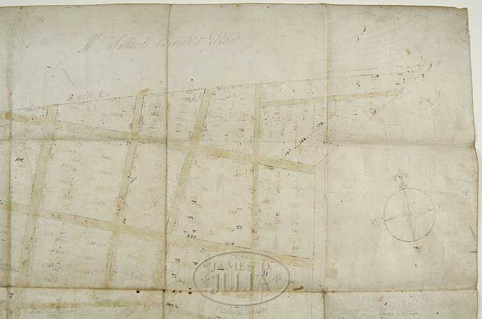
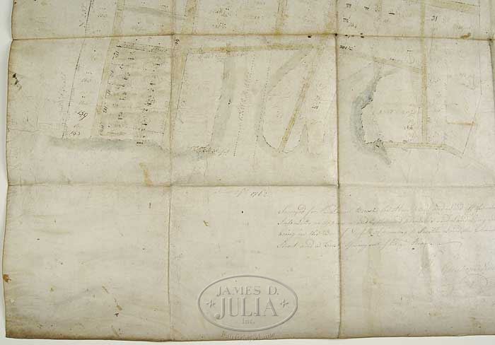
THE ORIGINAL HAND-DRAWN 1762 MAP OF NORFOLK VIRGINIA REFERRED TO AS THE “SAMUEL BOUSH PLAN OF 1762”. The pen and watercolor on original sheepskin dated June 29, 1762 surveyed by Gershom Nimmosons. The map titled “Mr. Samuel Boush’s Plan”. Scale: 160′ to the inch. Having a bottom inscription “Surveyed for Mr. Samuel Boush the above plan Laid off the same Into Lotts as Appear and by the said plan, the said Land Lying and being in the Bor. of Norfolk Adjoining to Smith’s Land, the Church Street and a Creek Issuing out of Elizth. River.” The plan showing water-colored edges, feet designations and water designation. Note:The Boush family was long entrenched in America before Samuel Boush I arrived in Norfolk, VA sometime prior to 1693. The Boushes were large land-owners in Norfolk, VA and Col. Samuel Boush was the first mayor in 1736. And the Boush family was instrumental in planning development in the borough of Norfolk, specifically in the areas later called Boush Street, Church Street, and Charles Street. Additional family items: a small lot includes prints of Charles and Catherine Boush II, a small engraving of the City of Norfolk, some items from George W. Boush and a cabinet card of Laura Foster Boush. SIZE: 22″ x 23-1/2″ PROVENANCE: Descended directly through the Boush family, this plan was on loan to the Chrysler Museum, Norfolk, VA from 1945 to 2012. CONDITION: Good condition for age. Edges soiled, some light staining, only minor edge bites and pin holes. 9-25239 (15,000-25,000)
Auction: Fine Art, Antiques & Asian - August 2012 Please Note: All prices include the hammer price plus the buyer’s premium, which is paid by the buyer as part of the purchase price. The prices noted here after the auction are considered unofficial and do not become official until after the 46th day. |